Review Cart.


Checkout Summary.

Total
Items:
> Total
Amount:
+ Delivery:+ Tax:= GRAND
TOTAL:

Send Order Pay with Paypal
View Cart () items.

Jumat, 29 April 2016

Garmin Zumo 390


Garmin Zumo 390


Deskripsi :
Navigator untuk pengendara motor

  • Layar 4.3” inche yang tajam, jelas terbaca diterik matahari, Layar sentuh bisa digunakan meski menggunakan sarung tangan
  • Kokoh, Tahan air IPX7¹, Tahan terhadap cipratan bahan bakar dan sinar ultra violet
  • Layanan riwayat Log untuk  pemeliharaan
  • Update peta seumur hidup
  • Hands-free Bluetooth di helm(dijual terpisah)
  • Panduan jalan melengkung untuk jalan yang berkelok dan naik
Didesain Oleh Biker untuk para Biker
Zūmo 390 memiliki ukuran layar 4.3”, layarsentuh yang mudah dibaca, meskipun kondisi terik matahari. Dengan bodi yang kokoh serta tahan air IPX7¹ dan tahan terhadap cipratan bahan bakar dan tahan dari sinar ultraviolet, , zūmo 390  dibuat untuk hidup dijalanan.
Kekuatan Bluetooth
Fitur tehnologi nirkabel Bluetooth pada zūmo 390, Hanya dengan menghubungkan Zumo dengan Phonsel pintar anda serta headset Bluetooth. Anda dengan mudah menerima panggilan tanpa harus mengangkat telp, melepas helm.. Anda juga bisa memanggil tempat tempat menarik lewat interface Buetoothnya Zumo, Cocok untuk perubahan rencana mendadak dan pit stop cepat untuk makan dan bahan bakar.
zūmo 390 bisa mengirimkan petunjuk suara ke headset yang kompatibel ataupun helm yang kompatibel(dijual terpisah). sehingga memungkinkan anda untuk Mendengar  nama jalan dan perintah navigasi memungkinka sementara anda fokus pada jalan.
Layanan Log Riwayat
Jarak yang sudah di tempuh ban, perubahan ban, tekanan ban, periksa rantai, ganti oli, ganti Busi: Biarkan Zumo 390 yang melacak semuanya. Gunakan Layanan Log Riwayat untuk tanggal pencatatan, jarak tempuh, dan pemeliharaan yang dilakukan.
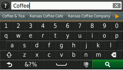
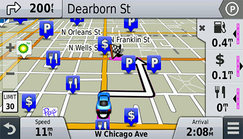
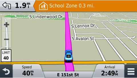
Alat navigasi
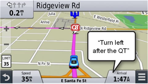
Fitur Lane assist  dengan tampilan persimpangan .Panah berwarna cerah menunjukkan posisi jalur yang tepat yang diperlukan untuk giliran berikutnya.
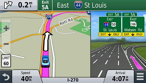
zūmo 390 memiliki fitureTracBack® jadi anda bisa menuju ketempat anda mulai melalui rute yang anda lalui. Layanan Exit  menampilkan pompa bensin dan restoran restoran yang ada dipintu keluar berikutnya. Fitur Skip memungkinkan anda untuk melewati/melewatkan waypoint selanjutnya dengan mudah.
Fitur tambahan yang menyenangkan
zūmo 390 sudah built in trip komputer dengan tampilan kompas. Juga dilengkapi dengan pengukur bahan bakar digital,sehinga anda bisa melacak berapa mil anda bisa naik sebelum berhenti untuk isi BBM. Ada indikator batas kecepatan sehingga anda tahu kapan harus memperlambat berkendara anda.
Rencanakan dan bagikan
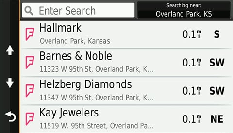
Rencanakan perjalanan anda berikutnya dengan  BaseCamp™. Anda bisa membuat rute dispanjang jalan tertentu,mencari, menyimpan, tempat menarik, termasuk atraksi lokal, restoran dan Pompa bensin. Kemudian, unggah rencana perjalanan anda ke Zumo dan ikuti
Garmin Adventures, didukung oleh BaseCamp, gratis, cara yang interakrif untuk mencatat dan membagikan berkendara anda. Dengan  BaseCamp,anda dapat menggabungkan track log,waypoin,Photo Geotag, Video YouTube®  dan masih banyak lagi ke petualangan yang bisa anda bagikan secara online. Garmin Adventures juga memungkinkan anda untuk menilai perjalanan anda, membaca ulasan dan mengunduh rute rute yang di bagi oleh pngendara lain other riders.
Monitor tekanan Ban dengan Mudah
zūmo 390 kompatibel dengan  Tire Pressure Monitor Sensor (dijual terpisah) yang bisa mengetahu tekanan ban. Tambahkan sensor TPMS pada tiap tiap bandan dengan mudah anda mengetahui tekanan ban pada layar zumo

Physical & Performance

Unit dimensions, WxHxD 5.12″W x 3.7″H x 1.18″D (13.0 x 9.4 x 3.0 cm)
Display size, WxH 3.7″W x 2.2″H (9.4 x 5.6 cm); 4.3″ diag (10.9 cm)
Display resolution, WxH 480 x 272 pixels, 480 x 272 pixels
Display type WQVGA color TFT with white backlight
Weight 9.5 ounces (270 g)
Battery rechargeable lithium-ion
Battery life up to 7 hours, up to 7 hours
Headphone jack/audio line-out Yes
High-sensitivity receiver Yes
Waterproof Yes (IPX7)

Maps & Memory

Preloaded street maps Yes
Includes lifetime map updates Yes
nüMaps Guarantee yes
3-D terrain view No
3-D buildings and landmarks view No
Built-in memory internal solid state
Accepts data cards microSD™ card (not included)
Waypoints/favorites/locations 1000

Features & Benefits

Features That Save Time & Money
Voice prompts (e.g. “Turn right in 500 ft.”) Yes (Internal speaker)
Speaks street names (e.g. “Turn right ON ELM STREET in 500 ft.”) Yes
Voice-activated navigation (operate device with spoken commands) No
Traffic compatible (routes around traffic with a receiver and subscription) Yes (in automotive mount)
Lifetime traffic updates (receive free lifetime traffic updates) No
Lane assist (guides to proper lane for navigation) Yes
Junction view (displays junction signs) Yes
myTrends™ (predicts your routes) No
trafficTrends™ (calculates routes based on predicted traffic flow) Yes
Auto sort multiple destinations (provides most direct route) Yes
Route avoidance (avoid highways, tolls etc.) Yes
XM® compatible for U.S No
Safe Navigation Features
Bluetooth® wireless technology Yes
Speed limit indicator (displays speed limit for most major roads in the U.S. and Europe) Yes
Where Am I? (find closest hospitals, police & gas stations, nearest address & intersection) Yes
Enhanced pedestrian navigation (guides you as you walk around town) no
Photo navigation (navigate to geotagged photos) No
View upcoming points of interest along route Yes
Custom POIs (ability to add additional points of interest) Yes
Garmin Lock™ (anti-theft feature) No
Customizable Features
Garmin Garage™ vehicles compatible (download car-shaped icons to your device) Yes
Garmin Garage™ voices compatible (download custom voices to your device) Yes
MP3 player No
Audio book player No

Additional Specs

Trip Planner: yes Trip Log: yes
Tire pressure monitor system: yes; individual sensors sold separately
Curvy Roads routing: yes
Power supplied to device power cable should be capable of up 12 V (typical) and up to 1 A. zūmo device power consumption is 5 V; 2 A.
This USB device is compatible with Windows® XP or newer and Mac® OS X 10.4 or later.
In the box :
  • zūmo 390
  • Preloaded City Navigator Indonesia & Navigasi.net
  • Motorcycle mount with power cable and mounting hardware
  • Automotive power cable
  • USB cable
  • Quick start manual
  • 1 Year warranty

Garmin Nuvi 57LM

Garmin Nuvi 57LM


Advanced Driving Navigation at a Value Price

  • Easy-to-use dedicated GPS navigator with 5.0-inch dual-orientation display
  • Preloaded with detailed maps of the lower 49 U.S. states with free lifetime¹ map updates
  • Garmin Real Directions™ guide like a friend using landmarks and traffic lights
  • Find new and popular restaurants, shops and more with Foursquare®
  • Direct Access simplifies navigating to select complex destinations, like malls and airports

Dedicated, Easy-to-use GPS Guidance

For driving directions on the road, put away the smartphone and power on your nüvi. nüvi 57LM is an easy-to-use, dedicated GPS navigator that does not rely on cellular signals and is unaffected by cellular dead zones. nüvi 57LM features sleek styling and a bright, 5.0-inch dual-orientation display, for use horizontally or vertically. Its included suction cup mount keeps it firmly in place.

Detailed Maps with Free Updates

nüvi 57LM arrives pre-loaded with detailed maps of the lower 49 U.S. states. With free lifetime¹ map updates, your routes are sure to reflect the most up-to-date maps, points of interest (POI) and navigation information available. New maps are available for download for the useful life of your GPS device, with no fees.

Garmin Real Directions


nüvi 57LM redefines “spoken turn-by-turn directions” with Garmin Real Directions, easy-to-understand driving directions that guide like a friend using recognizable landmarks, buildings and traffic lights. No more stress from trying to read street names. Instead, hear clearly spoken guidance, like “Turn left after the gas station.”

Foursquare Adds Millions of New POIs


nüvi 57LM makes it easy to find addresses and millions of POIs (points of interest) – that is, businesses, stores, restaurants or other destinations. Our POI database also includes accurate, relevant information sourced from Foursquare. Now, when you search, the most relevant Foursquare result appears at the top of the list. It’s an easy way to discover new and popular restaurants, shops and more.

Find Exactly Where You Need to Go


The Direct Access feature simplifies navigating to select complex destinations, like airports and shopping malls, by finding a place within a larger location. Direct Access even navigates through parking lots to find the entrance nearest your destination. When navigating to the mall, Direct Access gives additional location information for specific retail stores inside. For example, “Arriving at Woodfield Mall. Anthropologie is inside, on the upper level.”

Navigate Complex Interchanges with Ease

nüvi 57LM has lane assist with junction view that displays upcoming junctions and uses brightly colored arrows to indicate your proper lane.

Easier to Search, Quicker to Find


nüvi 57LM has a search field that makes it easy to find addresses and millions of POIs, in a single place. Now, simply enter a category (like “pizza”), an entire address (“1234 Sycamore Lane, Anytown, USA”) or a proper name (“Starbucks”) and nüvi 57LM quickly returns your results.

More Information At-a-glance


No need to search for a hard-to-read or nonexistent sign; with a glance at nüvi 57LM, you’ll see your current street. nüvi also displays speed limit, current speed and arrival time.
With the Up Ahead feature, you can easily find places you want without leaving the map. As you drive your route, Up Ahead constantly informs you of nearby services, including food, fuel and ATMs. Best of all, Up Ahead is customizable, so you can always know the location of favorite destinations along the way.

School Zone Warnings

nüvi 57LM issues an audible alert and displays an onscreen warning whenever you approach a school zone. The displayed speed limit also changes to reflect the school zone speed limit.

Add a Wireless Backup Camera


For a complete navigation solution, nüvi 57LM pairs with the BC™ 30wireless backup camera (sold separately. Professional installation recommended). Once connected, you can easily see vehicles, pedestrians and other obstacles right on the nüvi display, as you move in reverse.

One-stop Device Management

Use Garmin Express to keep your nüvi up-to-date. Garmin Express makes it easy to update maps and software, transfer favorites to and from devices, and install free custom vehicles and voices.

Physical & Performance

Physical dimensions 5.5″W x 3.4″H x 0.8″D (13.9 x 8.6 x 2.0 cm)
Display size, WxH 4.4″W x 2.5″H (11.1 x 6.3 cm); 5.0″ diag (12.7 cm)
Display resolution, WxH 480 x 272 pixels
Display type WQVGA color TFT with white backlight
Weight 6.4 oz (180.1 g)
Battery rechargeable lithium-ion
Battery life up to 2 hours
High-sensitivity receiver  YES

Maps & Memory

Preloaded street maps  YES
Includes lifetime map updates  YES
nüMaps Guarantee  YES
Built-in memory internal solid state
Accepts data cards microSD™ card (not included)
Custom POIs (ability to add additional points of interest)  YES
Waypoints/favorites/locations 1000

Navigation Features

Speaks street names (e.g. “Turn right ON ELM STREET in 500 ft.”) YES
Lane assist (guides to proper lane for navigation) YES
Junction view (displays junction signs) YES
Route avoidance (avoid highways, tolls etc.) YES
Speed limit indicator (displays speed limit for most major roads in the U.S. and Europe) YES
View upcoming points of interest along route YES

Additional

Additional
  • Preloaded maps: detailed maps of the lower 49 states
  • Trip Planner: yes
  • Trip Log: yes

Kelengkapaan :
  • nüvi 57LM
  • Preloaded with City Navigator® NT — Lower 49 states
  • Lifetime maps¹ (indicated by “LM” after model number on the box)
  • Vehicle power cable
  • Vehicle suction cup mount
  • USB cable
  • Quick start manual

Spectra Mobilemapper 20

Spectra Mobilemapper 20


Geographical Information Systems and Location Based Services are now being used in a wide range of applications and organizations. The growing need for geo-localization is naturally boosting the demand for efficient and affordable data collection solutions. Spectra Precision is leading the democratization of GNSS, enabling wider access to professional mapping. With MobileMapper 20, Spectra Precision makes it possible to deploy a professional accurate GIS receiver to any field work force.
Secure Your Field Work
A wide range of capabilities in a compact, lightweight design
Several days of battery life
Rugged and reliable
Unpack and Start Logging
Ready-to-use complete mapping solution for field and office
User friendly Windows® Embedded Handheld 6.5
Easy-to-use software for short learning curve and quick logging operations
Ideal for Data Maintenance or Inspection
Log your assets in real-time with 1 to 2 meter accuracy
Connect field and office work force for maximum productivity
Achieve half meter accuracy with post-processing
MobileMapper Field and Office Software: a complete solution
The Spectra Precision MobileMapper software suite includes all GIS features that professionals really need without the burden of complicated and rarely used functions, both on field and office sides.
Running on MobileMapper receivers, MobileMapper Field is the perfect solution for GIS data collection, asset management, area measurements, maps creation and updates. The software is very intuitive and easy to use, requiring minimum training. It also provides direct interface to external sensors for a complete solution.
The MobileMapper Office tool can be used to differentially post process raw GPS data collected with the MobileMapper Field software. Through an Internet connection, MobileMapper Office can automatically find and download the base data files that will match the collected raw data; it will compute corrected positions automatically.
Tune MobileMapper 20 with your Applications
With Windows Embedded Handheld 6.5 you may upload necessary utilities or software on your MobileMapper 20, to suit your next job. You can collect GIS/GPS points and maps via the GIS application of your choice, either a third party software such as ESRI ArcPad or the proprietary Spectra Precision application.
Feature Spectra MobileMapper 20
  • Real time meter accuracy
  • Ready to use mapping solution
  • Integrated communications
  • Outstanding battery life
  • Ruggedized for professional use
Technical Specifications
Channels: 20
Signals: GPS L1 and SBAS
Size (H x W x L): 2.5 cm x 16.9 cm x 8.8 cm
Weight: 380/310 g (without/with battery)
Operating temperature: -10 Celsius to +60 Celsius
Communication protocols: USB, Built-in WiFi, Bluetooth, and GSM/GPRS/HSPA

Trimble Juno 5B + Software TerraSync Standard

Trimble Juno 5B + Software TerraSync Standard


Work smart with smartphone-inspired mobile GIS
Your team will perform better when they’ve got the tools they need to get the job done. Trimble Juno 5 series handhelds combine must have functionality with the familiarity of a smartphone form-factor. Optimized for GIS-oriented field workflows, the Juno 5 is the smart solution your team can trust for standardizing inspections and asset management.
Bringing GIS out to the field
Everything a team needs for delivering professional geospatial field work is there, with high-sensitivity GNSS, Windows® Embedded Handheld operating system, Office applications and camera onboard. Together with Trimble TerraSync™ and GPS Pathfinder® Office software—designed to handle professional workflows—you can work with confidence in the data you are capturing.
A smarter approach to field productivity
It may look like a smartphone, but the Juno 5 series is all business. Rugged enough to meet military specs, with an IP65 rating, it has a large screen so you can easily view data or photos even in direct sunlight. You can be confident that your teams have a real, professional tool—built to work in even the toughest conditions.Combining the convenience of a smartphone with ruggedness, the functionality you need and professional software—the Trimble Juno 5 series is your flexible, real world asset management and GIS update tool.
Key Features
  • Familiar, easy-to-use, smartphone form factor
  • Works with professional software and built for GIS workflows
  • Big, sunlight readable screen so can really work with data
  • Rugged for work in all conditions

Trimble Juno 5D + Software TerraSync Standard

Trimble Juno 5D + Software TerraSync Standard


Work smart with smartphone-inspired mobile GIS
Your team will perform better when they’ve got the tools they need to get the job done. Trimble® Juno® 5 series handhelds combine must have functionality with the familiarity of a smartphone form-factor. Optimized for GIS-oriented field workflows, the Juno 5 is the smart solution your team can trust for standardizing inspections and asset management.
Bringing GIS out to the field
Everything a team needs for delivering professional geospatial field work is there, with high-sensitivity GNSS, Windows® Embedded Handheld operating system, Office applications, camera, and cellular connectivity onboard. Stay flexible and connected with the builtin phone and powerful modem to send and receive calls and data on the job, keeping your team productive, informed, and in touch. Together with Trimble TerraSync™ and GPS Pathfinder® Office software—designed to handle professional workflows—you can work with confidence in the data you are capturing.
A smarter approach to field productivity
It may look like a smartphone, but the Juno 5 series is all business. Rugged enough to meet military specs, with an IP65 rating, it has a large screen so you can easily view data or photos even in direct sunlight. You can be confident that your teams have a real, professional tool—built to work in even the toughest conditions.Combining the convenience of a smartphone with ruggedness, the functionality you need and professional software—the Trimble Juno 5 series is your flexible, real world asset management and GIS update tool.
Key Features
  • Familiar, easy-to-use, smartphone form factor
  • Works with professional software and built for GIS workflows
  • Big, sunlight readable screen so can really work with data
  • Truly a phone to stay in touch with the office, powerful modem for connected solutions
  • Rugged for work in all conditions

In The Box :
  • Unit
  • USB Data Cable
  • Wrist Lanyard
  • AC Power Supply
  • Stylus With Lanyard
  • Li-ion Battery

Magellan Explorist 110

 MAGELLAN EXPLORIST 110


  • 2.2″ Sunlight Readable color display
  • Pre-loaded World Edition Map
  • Perfect for Fishing, Hiking, Hunting or any outdoor adventure
Specification :
Device
  • Dimensions (English) : 2.2″ x 4.4″ x 1.4″
  • Dimensions (Metric) : 56mm x 111mm x 36mm
  • Weight (English) : 5.20z
  • Weight (Metric) : 147g
  • Battery Type : 2xAA
  • Battery Life : 18 Hours
  • Waterproof : IPX-7
  • Available User Storage : 500 MB/Not Applicable
  • CPU : 233MHz
  • Temperature Range (F) : 14F to 140F
  • Temperature Range (C) : -10C to 60C
  • Suspend Mode : Yes
  • Internal Memory : 2 GB
Screen
  • Display Resolution, WxH : QVGA, 240 x 320
  • Screen Size : 2.2″
  • Display Type : Color, Transflective
GPS & Sensors
  • GPS Accuracy : Up to 3-5 meters
  • High-Sensitivity : GPS SiRFstarIII™
  • Antenna Type : Multidirectional Patch
  • WAAS/EGNOS/MSAS : Yes
Mapping & Navigation
  • Preloaded Maps : World Edition
  • Points of Interest : Yes
  • Vertical Profile : Yes
  • Area Calculation : Yes
  • Hunt & Fish Calendar : Yes
  • Sun & Moon Information : Yes
  • Coordinates Systems & Datums : Yes
  • Audible Proximity Alarms : Yes
User Generated Content
  • Accepts GPX Files : Yes
  • Waypoints : 500
  • Routes : 25
  • Geocaches : 500
  • Legs Per Route : 25
  • Paperless Geocaching : Yes
  • Tracks : 10
  • Points Per Track : 5000
  • User Data Online Sharing : Yes
Interface & Communications
  • Communication Protocol : USB Mass Storage
  • USB Port : Yes
  • NMEA Output : Yes
  • PC Compatible : Yes

Magellan Explorist 310

Magellan Explorist 310


Waterproof handheld GPS receiver with core outdoor navigation features, expandable mapping, and paperless geocaching.
  • Preloaded with World Edition map
  • Brilliant 2.2” QVGA color screen
  • Upload detailed topo maps
  • Paperless Geocaching
Specification :
Device
  • Dimensions (English) : 2.2″ x 4.4″ x 1.4″
  • Dimensions (Metric) : 56mm x 111mm x 36mm
  • Weight (English) : 5.20z
  • Weight (Metric) : 147g
  • Battery Type : 2xAA
  • Battery Life : 18 Hours
  • Waterproof : IPX-7
  • Available User Storage : 500 MB
  • CPU : 400MHz
  • Temperature Range (F) : 14F to 140F
  • Temperature Range (C) : -10C to 60C
  • Suspend Mode : Yes
  • Internal Memory : 2 GB
Screen
  • Display Resolution, WxH : QVGA, 240 x 320
  • Screen Size : 2.2″
  • Display Type Color, : Transflective
GPS & Sensors
  • GPS Accuracy : Up to 3-5 meters
  • High-Sensitivity GPS : SiRFstarIII™
  • Antenna Type : Multidirectional Patch
  • WAAS/EGNOS/MSAS : Yes
Mapping & Navigation
  • Preloaded Maps : World Edition
  • Uploadable Maps : Yes
  • Points of Interest : Yes
  • Vertical Profile : Yes
  • Area Calculation : Yes
  • Hunt & Fish Calendar : Yes
  • Sun & Moon Information : Yes
  • Coordinates Systems & Datums : Yes
  • Audible Proximity Alarms : Yes
User Generated Content
  • Accepts GPX Files : Yes
  • Waypoints : 1000
  • Routes : 50
  • Geocaches : 10000
  • Legs Per Route : 50
  • Paperless Geocaching : Yes
  • Picture Viewer : Yes
  • Tracks : 50
  • Points Per Track : 10000
  • User Data Online Sharing : Yes
Interface & Communications
  • Communication Protocol : USB Mass Storage
  • USB Port : Yes
  • NMEA Output : Yes
  • PC Compatible : Yes
Diberdayakan oleh Blogger.